Human spatial cognition and experience

Human spatial cognition and experience
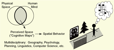
My major research interests are in the area of human spatial cognition and experience. Researchers from many disciplines study people’s knowledge about space or the environment, including geography, psychology, computer science, urban planning, architecture, and linguistics. In the field of geographic information science, or GIScience, the importance of studying cognitive issues has recently been recognized. The premise is that it is important to look at humans acting in space and reasoning about space (i.e., their cognitive processes), as well as the physical environment or information about space itself. It is in line with the major objective of behavioral approaches in geography (cognitive-behavioral geography), which focus on individuals’ cognitive processing. From this perspective, I study various issues of spatial cognition and experience, particularly the interaction between humans, space, and information about space, based on the theories and methods of cognitive and behavioral science.

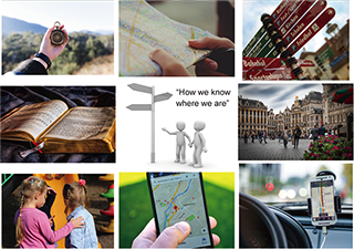
Space is a fundamental entity or concept for humans, particularly space at the environmental scale in which people’s daily activities take place—people live in the environment and the environment surrounds them. And then, how do people perceive the surrounding space? What do people know and how do they behave in the environment? What is people’s spatial knowledge like and how is the knowledge used in spatial orientation? How do people know where they are? Why do some people find their way without difficulty in a new environment and others easily get lost? Importantly, as people act in the environment, they acquire knowledge about it, store the knowledge in their heads, and use it to guide their behavior in adaptive ways. People’s behavior is thus based on psychological environments (i.e., environments that they perceive, conceive, and remember), as well as physical environments. I study a series of these basic psychological processes called cognitive mapping and the structure of acquired spatial knowledge (“maps in the head” or “cognitive maps”).
I am also interested in the psychology of space, namely, how people feel about their surrounding environments (people’s feelings and emotions in the environment). What kinds of experiences do people have in their spatial and social environments and how do they psychologically respond to the environments? Examination of these questions can be considered an application of the concept of user experience to the context of environmental perception. In particular, I examine the issue of environmental aesthetics with respect to people’s psychological evaluations of the quality of residential environments. I aim to gain insights about methods of urban planning that is tailored to the locale and residents; for example, the development of compact cities with an appropriate level of land use mix and the employment of performance-based regulations to improve the convenience of life as well as protecting residential environments.
Keywords for these lines of research include spatial abilities, sense of direction, spatial thinking, individual differences, mental representations, learning strategies, instruction and training, wayfinding and navigation, landmark selection, and navigation assistance.
Another research topic that I am interested in is the understanding and use of spatial representations, such as maps, images, diagrams, and various other types of visualizations (sometimes called geovisualizations). Spatial representations are used to show spatial (and nonspatial) information as an effective presentation format, but, at the same time, some people find such spatial representations difficult to understand and use. The issues of representation and communication of spatial information have attracted theoretical and practical attention particularly recently with the recognition of the importance of spatial thinking in academic disciplines and everyday activities and the advances in geospatial technologies. Spatial information, moreover, contains various kinds and degrees of uncertainty and ambiguity, inherent in the manner in which information about space is represented and described.
For the consideration of these issues, cognitive aspects of the user, or people’s knowledge and cognition of space, have significance. First of all, people differ in the ability to think spatially, especially to learn the environment accurately in the metric and configurational sense. Given such large individual differences, it is probably not viable to aim for the single best way to present spatial information that works for everyone and in every situation. Also, people differ in learning styles and preferences: some people prefer visual or spatial methods and others prefer verbal methods. Some people find it easier to be guided with a map, while other people want to be guided through verbal descriptions. Furthermore, in verbally describing space, people have different preferences for a spatial frame of reference, for example, either instructions given in a relative framework (“you will see the hotel to your left”) or instructions in an absolute framework (“you will see the hotel to the west”).
I study how to present spatial information effectively, adapting to the user attributes and navigational situation, especially in the context of the development of effective navigation assistance. Questions of concern include how to design user-friendly and context-aware navigation tools, how to provide navigation assistance that uses various sensory modalities, and how to adjust navigational instructions to good and poor wayfinders. Also, is there a good way to
Space is a unifying theme across many disciplines of science, technology, engineering, and mathematics. Among such spatial disciplines is geoscience: students need to master complex spatial tasks spanning a wide range of scales (e.g., using and making maps, visualizing geologic structures from field observations, or applying GIS operations such as buffering and overlaying), but many students have difficulty with such high-level spatial thinking. To help students master the skill, various instructional methods have been proposed, particularly using interactive 3-D visualizations and animations. I am interested in examining the effectiveness of these visualization techniques in the facilitation of students’ spatial learning and thinking. And more broadly, I study the characteristics of spatial thinking in geography and geographic information science; for example, the classification of geospatial concepts, the relationship of geospatial thinking and basic spatial ability, and expert knowledge in geospatial thinking.
From a societal point of view, the importance of spatial information has been recognized in the attempt to develop geospatial technologies and data infrastructures. The idea of ubiquitous computing (or the Internet of Things) aims to create a society in which people have universal access to information whenever and wherever they want it (the concept of “anytime, anywhere, and anyone”). An important question, then, is when and where one should provide information, in what format and for what kind of user or task. I am interested in the application of advanced geospatial technologies to real space and its effects on the user’s spatial cognition and experience. Such a spatially enabled society will merge information space and real space, and eventually create a city environment that is fully augmented by computational capabilities, just like a map with a scale of 1:1. How would people behave in such a future society? What would our sense of orientation and sense of place be like? In this regard, the question of spatial awareness in the age of satellite navigation has particular significance.
[Back]